
Graphic by National Weather Service

Audio By Carbonatix
Update published 8/20/2023 12:10 p.m.: The back end of the tropical wave is passing through the Straits of Florida, and its impact on South Florida will have cleared out by Sunday night. The system is heading west and has a moderate chance of developing in the Gulf of Mexico before approaching Texas.
In the middle of the Atlantic Ocean, Invest 98L strengthened into Tropical Storm Emily, the fifth named storm of hurricane season, packing sustained winds of 50 mph. The system is forecast to be pulled north by a trough into open ocean, posing no threat to Florida.
Off the coast of South America, another tropical disturbance, dubbed Invest 90L, has a strong chance of developing as it approaches Haiti and the Dominican Republic early this week. Most of the track models show it battering Hispaniola and then continuing north into open ocean while staying far off the coast of the Sunshine State.
The original story follows below.
If you had weekend plans to lounge by the beach, or perhaps shake ass on a Miami party boat under the late summer sun, good ol’ Mother Nature says: “Think again!”
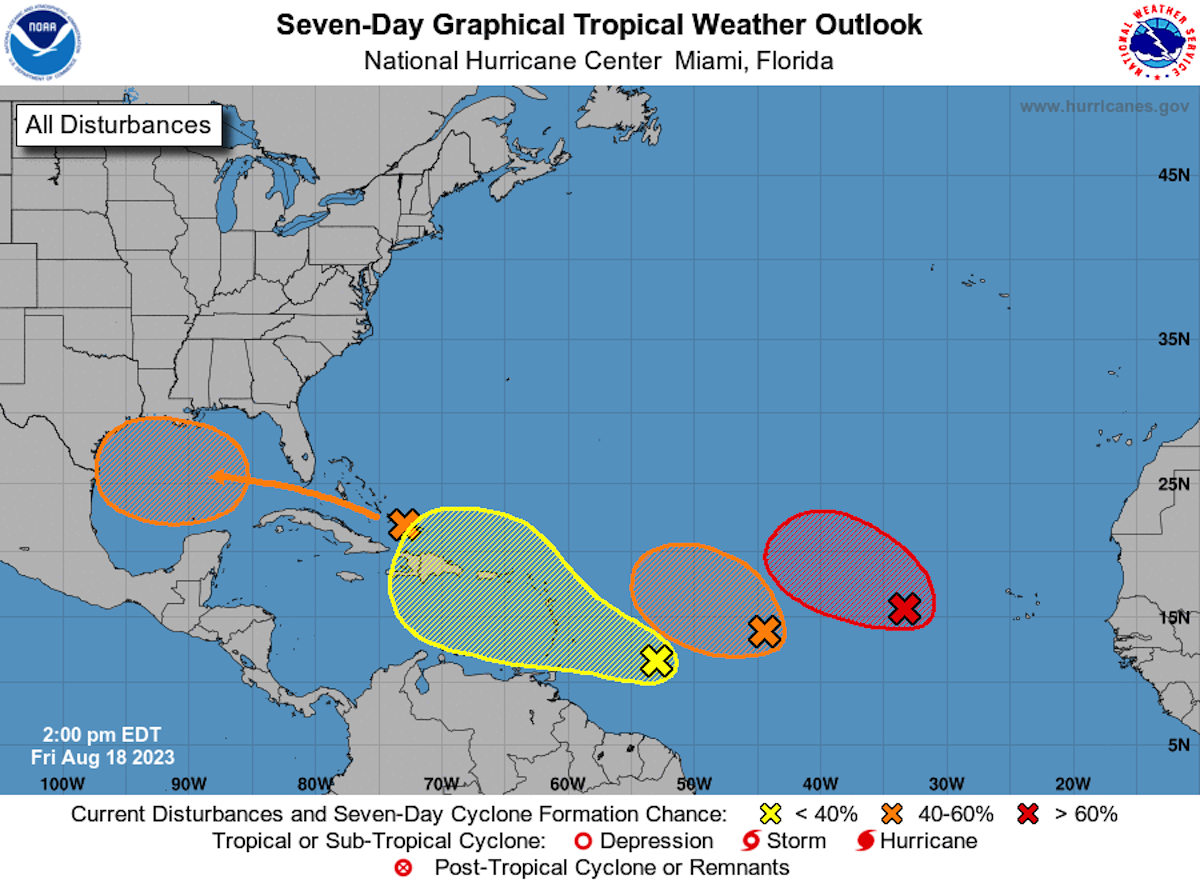
As the National Hurricane Center tracks several tropical disturbances across the central and eastern Atlantic and the Gulf of Mexico, a so-called “disorganized tropical wave” is expected to approach South Florida tomorrow – likely soaking the region with heavy showers and thunderstorms this weekend.
“This wave is NOT forecast to develop into a tropical system over the next two days,” the National Weather Service (NWS) in Miami clarifies, “although you will probably want to carry your umbrella.”
A disorganized tropical wave will be approaching S. Florida tomorrow, bringing increased chances for showers and thunderstorms this weekend.
This wave is NOT forecast to develop into a tropical system over the next two days although you will probably want to carry your umbrella pic.twitter.com/LeRfNQSvLc
— NWS Miami (@NWSMiami) August 18, 2023
Because the system is so disorganized (relatable!), the NWS says it isn’t expecting any widespread sustained wind impacts. However, coastal residents could expect a little more breeze than usual, with around 15 to 20 mph gusts of wind, as well as some strong showers or storms that might pack hefty gusts.
CBS Miami meteorologist Lissette Gonzalez says that South Florida should expect a “soggy” Saturday, with heavy rain throughout the morning and afternoon. Sunday morning is expected to bring more showers, though rain chances clear out Sunday afternoon.
“Bottom line, you’re going to want to keep the rain gear close,” Gonzalez says.
After a relatively quiet summer, it’s been a busy week in the Atlantic. The National Hurricane Center is currently monitoring three other systems that are still thousands of miles from Florida.
Off the coast of Africa, Invest 98L has a 70 percent chance of development in the next week, but most models show it veering north in open ocean. To the west of that system, Invest 99L is likely headed on a more westerly path that could bring it near the Lesser Antilles, though its chances of developing into a tropical storm remain uncertain. Another system churning off the coast of South America is also being tracked by the National Weather Service. While the European Centre for Medium-Range Weather Forecasts does not show the three systems approaching South Florida, forecasts are in the early stages and subject to change.
As students returned to school across South Florida this week, the NWS issued a handful of flood advisories across parts of Miami-Dade and Broward. Forecasters had urged people to take shelter from heavy storms that battered the area and triggered flight delays at Miami International Airport.
Meanwhile, over in the Pacific, Hurricane Hilary has grown rapidly into Category 4 strength off Mexico’s Pacific coast. It’s expected to weaken before reaching Southern California as the area’s first tropical storm in 84 years.
This is a breaking story. Check back for updates.