

Satellite imagery from the National Hurricane Center

Audio By Carbonatix
Tropical Storm Lee strengthened into a hurricane Wednesday evening and is forecast to rapidly intensify into a Category 4 storm before passing north of Puerto Rico early next week.
Churning 950 miles southeast of the Leeward Islands, the storm is expected to become the third major hurricane of the season, with sustained wind speeds reaching at least 130 mph by early Friday.
“The environment around the cyclone looks ideal for rapid intensification. The models are in fairly good agreement that significant strengthening should begin later today and continue into the weekend, when Lee will likely reach its peak intensity,” the National Hurricane Center said in a 5 a.m. advisory on September 7.
The storm is currently packing sustained winds of 70 mph as it tracks northwest in the Atlantic Ocean.
Hopes that Florida and the southeastern U.S. will avoid a direct hit have been fueled by extended models that show Lee potentially making a sharp northward turn next week in open ocean. However, meteorologists are stressing that it’s too early to tell whether the predicted track will hold steady.
Miami meteorologist Brian McNoldy tells New Times any impact on the Sunshine State would be longer than a week away, which is too far out to ensure accurate predictions.
“The models are in very good agreement on the track for the next 5-6 days…. Beyond that, it becomes increasingly uncertain as usual,” McNoldy says.
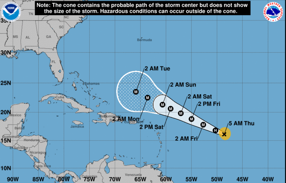
Forecasts indicate that the Leeward Islands may avoid a direct hit from Hurricane Lee.
Graphic by National Hurricane Center
In the nearer term, the National Hurricane Center says there is a roughly one-in-four chance that the Leeward Islands will experience tropical storm-force winds from the southern edge of the hurricane.
“As Lee slowly gains latitude and becomes significantly stronger, its wind field is forecast to expand. This is expected to result in a large area of high seas extending well away from the core of the system,” the National Hurricane Center’s 5 a.m. advisory stated.
Hurricane hunters will soon be flying plane missions into the tropical cyclone to gather more data on the storm. Orlando meteorologist Jonathan Kegges wrote that a dip in the jet stream is forecast to move into the southern U.S. and contribute to Lee’s anticipated northern turn.
“A complex jet stream pattern over northern North America is adding to the uncertainty after Lee lifts north of the Caribbean,” Kegges wrote.
Kegges suggested that “a later turn north would increase the chances of land interaction” along the central-to-north region of the U.S. coast.
Hurricane season, which lasts through November, is near its peak. Meteorologists are predicting above-average activity for the remainder of the season, though Lee is currently the only system in the Atlantic threatening the U.S.