

Photo by akipple/Adobe Stock

Audio By Carbonatix
Independent Journalism in Miami Needs You
We need to raise $10,000 by August 9 to support the reporting our community depends on. Reader support keeps us independent and is playing a larger role in funding local journalism and shaping what comes next. If you believe independent local journalism matters, make a contribution today.
A low-pressure system in the Gulf of Mexico has been dumping precipitation over the past few days, and today appears to be no exception, according to the National Weather Service (NWS) forecast.
You could look out your own damn window and guess that today’s forecast includes rain. The official word from the NWS in Miami this afternoon:
“Mostly cloudy, with a high near 87. Southwest wind around 10 mph. Chance of precipitation is 70 percent. New rainfall amounts between a quarter and half of an inch possible.”
And tonight? The fireworks? That might be another story: As of 1 p.m., the NWS foresees “a 50 percent chance of showers and thunderstorms. Mostly cloudy, then gradually becoming mostly clear, with a low around 78. Southwest wind around 7 mph. New rainfall amounts between a tenth and quarter of an inch, except higher amounts possible in thunderstorms.”
Need a visual aid?
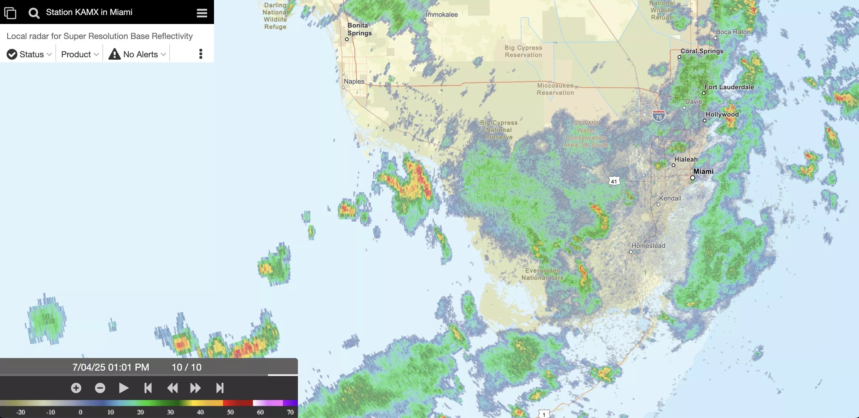
Yes, that’s wet. But the evening forecast isn’t quite so dire.
National Weather Service (NWS) screenshot
In the meantime, north of us, the National Hurricane Center (NHC) continues to track a system that’s lurking just off the Atlantic coast.
The latest report from the NHC foresees a 70 percent chance of continued development: “Satellite wind data indicate that the system located about 150 miles
off the northeast Florida coast has become better defined today with
an area of strong winds located on its east side,” the hurricane center reports. “Showers and
thunderstorms are also persisting near and to the east of the
center. A short-lived subtropical or tropical depression could
form later today or on Saturday while the system drifts generally
north-northwestward. This low is expected to move inland over the
southeastern U.S. by early Sunday…. Regardless of
development, heavy rainfall is possible across portions of
west-central and southwestern Florida through early Saturday, and
across coastal sections of the Carolinas beginning later on
Saturday.”
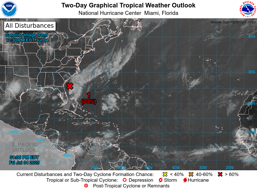
Keeping an eye to the north of us
National Hurricane Center graphic
This should serve as a reminder to South Floridians to always keep abreast of weather forecasts during hurricane season, which runs from June 1 to November 30.
“People need to pay particular attention in October and November, when conditions are better for stronger storms,” NWS meteorologist Sammy Hadi tells New Times. “It only takes one hurricane to change a community, so always be prepared.”
On June 24, the World Meteorological Organization named Tropical Storm Andrea the first tropical storm of the 2025 Atlantic hurricane season. Andrea dissipated hundreds of miles from any landmass without much fanfare a day later. It’s not uncommon for the first named storm to develop close to a month into a hurricane season, Hadi tells New Times.
In April, researchers at Colorado State University predicted above-normal activity for the 2025 Atlantic hurricane season, with 17 named storms and nine hurricanes on the horizon this year.
A warmer-than-normal tropical Atlantic, paired with potential La Niña conditions, abnormally low sea surface temperatures in the central and eastern equatorial Pacific, has created a dynamic environment for intense hurricanes to strike the Atlantic coast, according to the report from the university’s Department of Atmospheric Science.
Miami was spared by the busy 2024 hurricane season, and researchers’ 2025 predictions include a similarly low 26 percent chance that a major hurricane will strike somewhere along Florida’s Atlantic coast. Forecasters predict a 92 percent chance of a named storm striking somewhere in Florida this year and a 35 percent chance the state sees a major hurricane within 50 miles; both numbers are slightly down from 2024, according to the university.
The South Florida hurricane season peaks between August and October, and more hurricanes have struck South Florida in October than in any other month, Brian McNoldy, a senior research associate at the University of Miami’s Rosenstiel School of Marine, Atmospheric, and Earth Science, has previously told New Times.
The university also predicted a busy Atlantic hurricane season in 2024, anticipating anywhere from 17 to 25 named storms, four to seven of which it forecasted would become major Category 3 or higher hurricanes. The season actually featured 18 named storms, 11 hurricanes, and five major hurricanes.