
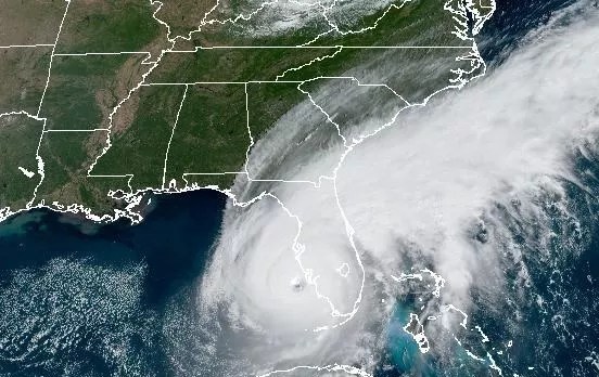
Photo by the National Environmental Satellite, Data, and Information Service (NESDIS).

Audio By Carbonatix
Live blog updates on Hurricane Ian ended September 29.
Hurricane Ian made landfall in Florida on Wednesday, September 28, bringing 150 mph winds and inundating communities on the state’s west coast with a historic storm surge that destroyed entire city blocks. As it moved across the state Thursday as a tropical storm, Ian generated catastrophic flooding from the Orlando metro area to St. Johns County.
Coast-to-coast damage from Ian all but ensures that it will go down in history as one of the most destructive storms to ever strike Florida.
9/29 9:35 p.m.
At an evening press conference, Florida Governor Ron DeSantis said that more than 700 people have been rescued from Florida’s Gulf Coast.
Rescue operations were conducted today in Fort Myers, Sanibel, Fort Myers Beach, Marco Island, barrier islands in Charlotte County, and other decimated communities. First responders went home to home to check for stranded residents, while also responding to reports of missing loved ones.
“Some of the damage was almost indescribable … to see a house, just sitting in the middle of Estero Bay,” DeSantis said.
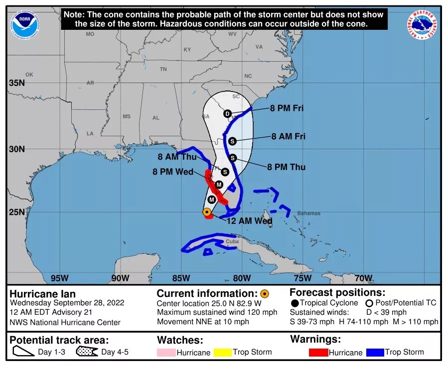
Ian restrengthened into a hurricane late in the day after moving off the coast of northeast Florida.
The storm currently is packing sustained winds of 75 mph and could strengthen before landfall in South Carolina tomorrow, according to an 8 p.m. advisory by the National Hurricane Center.
“On the forecast track, Ian will approach the coast of South Carolina on Friday. The center will move farther inland across the Carolinas Friday night and Saturday,” the advisory stated.
5:40 p.m.
At a Thursday afternoon press conference in Charlotte County, Florida Governor Ron DeSantis said that rescue operations were ongoing to save stranded residents from Sanibel Island on Florida’s west coast.
The U.S. Coast Guard, local law enforcement, and disaster-response specialists from Florida’s Urban Search and Rescue teams were participating in the effort, according to DeSantis. The operation relied heavily on helicopter rescues, as a storm-damaged bridge to the island had collapsed, he said.
“Sanibel … is destruction,” DeSantis said. “It was a beautiful place. It got hit with a really biblical storm surge.”
President Joe Biden hinted at a potentially dire death toll from Hurricane Ian.
“The numbers are still unclear but we are hearing early reports of what may be substantial loss of life,” Biden said at a separate press conference, held at Federal Emergency Management Agency (FEMA) headquarters.
When asked about his relationship with Gov. DeSantis, Biden said, “It’s totally irrelevant but I’ll answer it: very fine.”
“This is not about anything having to do with our disagreements politically,” Biden said. “This is about saving people’s lives, homes and businesses. I’ve talked to him four or five times already. And it’s not a matter of my disagreements with him on other items.”
FEMA administrator Deanne Criswell said that the federal government is looking to expand the list of counties where individuals will be eligible for federal assistance under Biden’s major-disaster declaration this morning.
Currently, individuals are eligible in Charlotte, Collier, DeSoto, Hardee, Hillsborough, Lee, Manatee, Pinellas and Sarasota counties. Grants are available “for temporary housing and home repairs, low-interest loans to cover uninsured property losses and other programs to help individuals and business owners recover from the effects of the disaster,” according to FEMA. Inquiries can be initiated with FEMA at disasterassistance.gov or 1-800-621-3362.
Statewide, more than 2.6 million customers are without power as of 4:50 p.m., according to estimates from PowerOutage.us, which tracks 11.1 million Florida customers
Eric Silagy, president of Florida Power & Light, indicated that as of roughly 2 p.m., there were 1.2 million FPL customers without electricity. He said more than 700,000 customers’ power had been restored.
Scenes of widespread destruction from Florida’s Gulf Coast continued to emerge throughout the day. Once the surge waters receded in Fort Myers Beach, the remains of leveled buildings could be seen lining the streets.
DEVASTATING. I was one of the few people that made it onto Fort Myers Beach this morning before it was shutdown. I have no words. @CBSMiami pic.twitter.com/taeQ8tz1al
— Nicole Lauren (@NLaurenTV) September 29, 2022
1:10 p.m.
Severe flooding has stretched from central Florida to the northeast Florida coast. Among other inundated municipalities, the city of Kissimmee is underwater.
Extensive flooding in our area remains a serious situation for Kissimmee residents. Shelter in place as first responders continue rescue operations. If you have an emergency, call 9-1-1. pic.twitter.com/RGn0HWzCj0
— City of Kissimmee (@CityofKissimmee) September 29, 2022
The National Hurricane Center (NHC) said it expects Ian, now a tropical storm, to restrengthen into a hurricane as it drifts over the Atlantic Ocean.
“As the system approaches South Carolina, Ian should maintain this intensity, and Hurricane Warnings have been issued for the entire coast of South Carolina,” the NHC said.
This morning, President Joe Biden authorized a major disaster declaration in Florida that will provide federal funding to aid in the recovery effort.
11:15 a.m.
The National Hurricane Center’s 11 a.m. advisory indicated the storm was 25 miles northeast of Cape Canaveral, moving off Florida’s northeast coast.
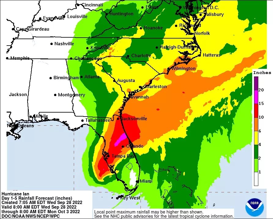
Ian has been downgraded to a tropical storm, with sustained wind speeds of 70 mph. Though its winds died down after landfall on the west coast of Florida, the storm continued to wreak havoc as it moved inland. The Orlando Sentinel reported that Orange, Seminole, Osceola and Volusia counties were drenched with rain, with some areas receiving 15 inches.
The National Hurricane Center said that Ian is “producing catastrophic flooding over east-central Florida.” The storm is now forecast to move offshore and approach South Carolina on Friday.
Reports of high-water rescues across central Florida were flowing in Thursday morning.
An Osceola County deputy became trapped in floodwaters and had to be rescued via airboat, ClickOrlando reported.
Meanwhile, an elderly Deltona-area resident reportedly died after he stepped outside his home during the storm.
“Deputies responded to a home … near Lake Bethel around 1 a.m. after the victim’s wife reported he disappeared after heading outside. While searching for him, deputies found his flashlight, then spotted the victim unresponsive in a canal behind the home,” the Volusia County Sheriff’s Office said.
8:30 a.m.
Coastal areas of Lee County and Collier County are in ruins. A historic storm surge overtook heavily populated cities from Naples to Fort Myers and beyond.
A bridge to Sanibel Island, one of the hardest hit areas, has collapsed.
Search and rescue efforts swung into gear Thursday morning, with the Lee County Sheriff’s Office saying it had deployed deputies to devastated communities. Lee County Sheriff Carmine Marceno reportedly told Good Morning America that while he does not have confirmed numbers, he fears hundreds died in the storm.
The vast majority of households in Lee County remained without power Thursday morning.
Statewide, more than 2.5 million customers had no electricity, according to PowerOutage.us, which tracks power outages among approximately 11.1 million customers in Florida.
#BreakingNews: An approximately 50-65 foot section of the Sanibel Causeway Bridge has fallen into the Gulf of Mexico. @NBC2 pic.twitter.com/vOI2EvyVOY
— Gage Goulding – NBC2 (@GageGoulding) September 29, 2022
More scenes of desperation emerged Wednesday evening, including footage of a Naples fire department rescuing a motorist trapped in flood waters.
Images of water rapidly filling up homes bode poorly for the prospect of widespread drowning deaths. Storm surge is generally the most deadly element of a hurricane, according to the National Oceanic and Atmospheric Association.
Got this from a friend in #Naples – just so sad. â¦@ActionNewsJaxâ© #Ian pic.twitter.com/HtC0CtG228
— Jason Brewer (@JBrewerBoston25) September 28, 2022
9/28 8:15 p.m.
More than 1.5 million customers in Florida are without electricity this evening as Hurricane Ian moves across central Florida.
The National Hurricane Center (NHC) said in its 8 p.m. advisory that Ian has sustained winds of 115 mph. The storm center is roughly 30 miles northeast of Punta Gorda and 95 miles southwest of Orlando.
“On the forecast track, the center of Ian is expected to move across central Florida tonight and Thursday morning and emerge over the western Atlantic by late Thursday,” the NHC said.
Curfews will be in place tonight in Lee, Sarasota and Charlotte counties.
9/28 7:10 p.m.
During an evening press conference, Florida Gov. Ron DeSantis called Hurricane Ian one of the “top five” major hurricanes to ever hit the Florida Peninsula, comparing the storm to Hurricane Andrew.
Evacuation orders have been issued in Clay, Flagler, Nassau, St. Johns, Putnam, and Sumter counties, the governor said. Low lying areas along the St. Johns River are forecast to see major flooding as Ian moves past southwest Florida and across the state. State meteorologists estimate that the storm surge and flooding in the southwest have likely peaked and will soon subside.
DeSantis said he sent a letter to President Joe Biden requesting a major disaster declaration for Florida and full reimbursement for emergency services and disaster assistance for 60 days. The governor said that while the federal government normally performs preliminary damage assessments before issuing such a declaration, he has asked for immediate action.
Emergency communications are down in Lee and Collier county, and 911 calls are being rerouted to neighboring county emergency services.
DeSantis and Florida Division of Emergency Management Director Kevin Guthrie warned people to stay away from standing water even after the storm surges subside, as many fatalities occur after the brunt of a hurricane hits the mainland.
Those who wish to donate money for disaster relief can contribute to the Florida Disaster Fund, while those who wish to give hands-on help can volunteer at VolunteerFlorida.org.
9/28 7:00 p.m.
Miami-Dade Fire Rescue’s Urban Search and Rescue Team is mobilizing to help out with the Hurricane Ian recovery effort.
The team AKA Florida Task Force One is trained in rescue operations, structural assessment, disaster recovery planning, advanced medical care and logistics support, among other fields.
“This is one of the biggest teams deployed to the area, and I am grateful we can lend a helping hand to all those affected by this devastating storm,” Miami-Dade Fire Chief Raied Jadallah said.
The task force has experience aiding in major disasters including the Surfside building collapse, Hurricane Katrina, and major earthquakes overseas.
9/28 6:10 p.m.
Hurricane Ian’s eye has moved onto mainland Florida. The National Hurricane Center stated in its 5 p.m. advisory that the storm center was 5 miles east of Punta Gorda in Charlotte County. When the eye passed over the area, witnesses described dead calm before the turmoil resumed.
The hurricane remains a Category 4 storm, with sustained wind speeds of 140 mph.
9/28 5:50 p.m.
Scenes of unbridled destruction are still unfolding along Florida’s Gulf Coast, marking a historic weather event. In Fort Myers Beach, buildings were ripped off their foundations and were floating around the city streets.
Absolutely jaw dropping footage continues to come out of Fort Myers Beach, Florida. #Ian https://t.co/ubHaCTQEo7
— Zach Covey (@ZachCoveyTV) September 28, 2022
Houses are wiped off their foundations and seen floating down streets in Fort Myers Beach as storm surge from Hurricane #Ian moves in.
📹 Cathy Haggins pic.twitter.com/Zw1IOXbgQY
— Zach Covey (@ZachCoveyTV) September 28, 2022
9/28 3:10 p.m.
Sarasota County officials say they are no longer responding to emergency calls. Conditions are too dangerous on the ground to trek out into the community, they say.
The National Hurricane Center meanwhile is stressing that the storm’s impact will not be limited to Florida’s west coast. As the storm moves inland across the middle of the state, widespread and destructive flooding is expected.
Cities from Orlando to Jacksonville could experience up to 15 inches of rain, with some communities receiving up to 20 inches.
The National Hurricane Center warned that Hurricane Ian will bring heavy rains and flooding across central Florida even after its wind speeds lose strength and it is reclassified as a tropical storm.
Image by National Hurricane Center
9/28 1:50 p.m.
Weather data company RadarOmega’s camera captured just how violent Hurricane Ian’s winds were on Sanibel Island before the device was ripped off its mount and carried away in the flood water.
LAST MOMENTS OF SANIBEL ISLAND SURGE PACK: Unfortunately, our @cyclonePORT was taken by the extreme winds and storm surge just moments ago. Here are the last moments on camera. @ryanhallyall pic.twitter.com/02a8hl4x2L
— RadarOmega (@RadarOmega) September 28, 2022
9/28 1:35 p.m.
Hurricane Ian’s storm surge overtook several blocks of Fort Myers Beach. The remnants of wrecked buildings floated through the floodwaters near submerged vehicles.
Major storm surge in Fort Myers Beach from a @winknews viewer. #flwx #Ian @spann @StormHour pic.twitter.com/9qwr7OSl2v
— Dylan Federico (@DylanFedericoWX) September 28, 2022
I don’t know if Fort Myers Beach could be in a worse position. Incredible onshore push as #HurricaineIan now moves onshore. Look at how high the water is! This camera is at least 6 feet above the ground with debris in the water pic.twitter.com/a82GIB3ETq
— Chris Bouzakis (@ChrisBouzakis) September 28, 2022
Some streets of Sanibel Island meanwhile were completely underwater as the storm passed through.
9/28 12:50 p.m.
The National Hurricane Center issued warnings to residents in the area of Cape Coral, Boca Grande, Sanibel Island, Englewood, Grove City, Rotonda, and Placida to stay inside and not attempt evacuation as they are currently under an “extreme wind warning.”
“You need to get into the interior of your home and begin to brace for a period of sustained, damaging, and potentially devastating winds. Do not venture outside at all,” said Jamie Rhome, acting director of the National Hurricane Center.
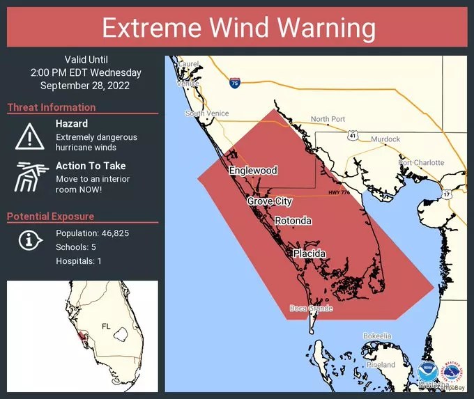
An extreme wind warning was issued for communities along Florida’s west coast as Hurricane Ian made landfall on September 28, 2022.
Graphic by the National Hurricane Center
9/28 12:30 p.m.
Storm chaser and self-described “extreme meteorologist” Reed Timmer reported devastating wind damage on Pine Island as Hurricane Ian’s eyewall began to hit Lee County.
More from the #eyewall #hurricaneian pic.twitter.com/chBYGBcLMb
— Reed Timmer, PhD (@ReedTimmerAccu) September 28, 2022
9/28 12:20 p.m.
A small clan of assclowns were caught on camera being tossed around by large waves as they waded into the ocean near a Lee County pier as Hurricane Ian approached.
Meteorologist Zach Covey took the occasion to remind the public that swimming in the ocean during a near-Category 5 hurricane is not safe.
New video just in from Fort Myers, FL shows swimmers getting into the storm surge as Hurricane #Ian approaches.
This is EXTREMELY dangerous. I can’t believe I have to say this…. DO NOT GET INTO THE WATER! pic.twitter.com/jsoUPvX8uC
— Zach Covey (@ZachCoveyTV) September 28, 2022
9/28 11:40 a.m.
The National Hurricane Center reports that Ian’s eyewall is moving onshore in southwest Florida. “Catastrophic storm surge” flooding and destructive waves are expected along the Gulf Coast from Englewood to Bonita Beach.
Naples is receiving intense wind and rain as bystanders share footage of ocean water crashing against the top of the pier at Naples Beach.
The storm caused an electrical line to collapse and catch fire outside Tin City Waterfront Shops, where debris from fallen palm fronds litter the streets.
Tin City #Naples #Ian https://t.co/4HUt2pMQNh
— Brigid #LOCK HIM UP ALREADY (@DataDivaFL) September 28, 2022
9/28 10:50 a.m.
Images of waist-deep water inundating a neighborhood in the Mayabeque province of Cuba provide a glimpse of what may be in store for some communities in central Florida.
Hurricane Ian moved across Cuba on September 27, striking Pinar del Rio and other provinces in the western region of the country. A nationwide power outage has affected virtually all of Cuba’s 11 million residents.
According to Cuban media, the storm killed at least two people in the island nation.
#Cuba en el Surgidero de Batabanó este es el escenario: decenas de casas bajo el agua tras el paso del #HuracanIan. Hasta el momento se desconoce cuántas personas han sido afectadas por este fenómeno. #Hurricane #HurricanIan pic.twitter.com/7KHeBaJBSX
— Daniel Benitez (@danielbnews) September 27, 2022
9/28 10:20 a.m.
Florida Division of Emergency Management Director Kevin Guthrie is urging Floridians who decided to shelter in place to stay indoors. Hurricane Ian may make landfall as a Category 5 this afternoon.
“The hurricane is projected to make landfall this afternoon along the Charlotte County coast,” Guthrie said at a morning press conference.
Guthrie said tropical storm-force winds will be felt throughout the state.
Florida Power & Light is reporting more than 18,400 customers without power in Miami-Dade County, 10,000 in Broward County, and 6,500 in Palm Beach County.
Florida Governor Ron DeSantis noted last night that in the coming days, millions of Floridians will likely be without electricity while crews repair widespread destruction to the power grid.
9/28 9:45 a.m.
Footage is emerging of water receding from coastal areas spanning from Tampa to Port Charlotte Harbor.
Hurricanes sometimes cause water to be pushed seaward in a phenomenon called “negative surge,” which can be a prelude to a subsequent storm surge.
Water getting pulled out of Port Charlotte Harbor, just like with Irma! Don't see any stranded Manatees
W/ @JustonStrmRider Hurrican #Ian pic.twitter.com/flutbpwGq9— Simon Brewer (@SimonStormRider) September 28, 2022
Video from Matt Tilman of Bayshore Blvd in Tampa. The bay being sucked out. #hurricaneian #ian pic.twitter.com/F54Lv1r5KV
— Jordan Steele (@JordanSteele) September 28, 2022
9/28 9:15 a.m.
Hurricane Ian is roughly 50 miles west of Naples with sustained winds of 155 mph, just 2 mph shy of a Category 5 storm. The storm is moving northeast at 10 mph, with landfall around Lee County imminent.
The National Hurricane Center is forecasting peak storm surge for the following areas: Englewood to Bonita Beach 12-18 ft; Charlotte Harbor 12-18 ft; Bonita Beach to Chokoloskee 8-12 ft; Chokoloskee to East Cape Sable 5-8 ft.
9/28 8:25 a.m.
Debris was strewn across Delray Beach after a tornado destroyed buildings in the Kings Point community Tuesday night. Overturned vehicles and downed trees lined a residential parking lot, and one building had a gaping hole where a tree toppled into the structure.
Residents in Kings Point Community in Delray Beach waking up to damage after possible tornado went through area overnight. pic.twitter.com/3Efabsxuc7
— Kara Duffy (@KaraDuffyCBS12) September 28, 2022
9/28 7:00 a.m.
Hurricane Ian rapidly intensified overnight into a Category 4 storm. Its sustained wind speeds have been clocked at 155 mph, only two mph away from making it a Category 5 hurricane.
“We are now forecasting a catastrophic storm surge of 12 to 16 ft from Englewood to Bonita Beach, Florida,” the National Hurricane Center (NHC) said in a 7 a.m. advisory.
The core of the storm will move onto coastal areas of central west Florida within the next few hours.
Footage of the storm surge and extensive water damage in Key West is a harbinger of what’s to come, on a much greater scale, on Florida’s Gulf Coast Wednesday. Images collected by journalist Gwen Filosa show widespread flooding and destruction in the Florida Keys on September 27.
8:45 pm at pier off White Street in Key West. I didn’t take this, a friend sent it to me. pic.twitter.com/ofugIOyNac
— Gwen Filosa (@KeyWestGwen) September 28, 2022
Key West this afternoon as the Keys prepared for tropical storm conditions from Ian. #Ian #KeyWest #florida #tropicalstorm pic.twitter.com/3mK86Pefkr
— Gwen Filosa (@KeyWestGwen) September 27, 2022
9/28 12:00 a.m.
In one of its final pre-landfall forecasts for Hurricane Ian, the National Hurricane Center said the west coast of Florida will begin to experience hurricane-strength winds the morning of Wednesday, September 28. The NHC said the eyewall of the hurricane is likely regenerating and that the storm’s core could strengthen overnight as a result.
The largest storm surge levels, potentially 8 to 12 feet, are anticipated from the middle of Longboat Key to Bonita Beach, including Charlotte Harbor, the NHC said.
Catastrophic flooding is expected in central Florida as Hurricane Ian rips across the region on Wednesday and Thursday.
Roughly 8,000 customers in the state were without power Tuesday evening after the outer bands of the hurricane whipped through.
“That number will be into the millions relatively shortly,” said Florida Governor Ron DeSantis at an 11 p.m. press conference.
The governor said that while coastal areas may bear the initial brunt of Hurricane Ian, residents of inland Florida should not let their guard down.
“What’s gonna happen is – this is a relatively slow-moving storm now – once it actually reaches landfall, it’s likely to go to a trickle. That’s going to dump an enormous amount of rain on the state of Florida,” the governor said. “It’s going to have major impacts in places like Osceola County, Orange County.”
An 11 p.m., September 27, forecast for Hurricane Ian’s arrival in Florida.
Forecast by the National Hurricane Center
9/27 9:45 p.m.
Reports of a nationwide blackout in Cuba emerged this evening after Hurricane Ian ripped through the island nation. The storm made landfall as a Category 3 storm in the Pinar del Rio province of western Cuba Tuesday in the early morning hours.
9/27 9:20 p.m.
The National Hurricane Center (NHC) said Hurricane Ian, which has sustained winds currently clocked at 120 mph, is forecast to strengthen tonight before approaching Florida’s west coast. The NHC reiterated that the storm is approaching the state as “an extremely dangerous major hurricane.”
The NHC estimates that the Florida Keys and South Florida will be inundated with 6 to 8 inches of rain from Ian, with isolated totals exceeding 12 inches. Central and northeast Florida will receive 12 to 18 inches of rain, with some areas exceeding 24 inches.
“Widespread catastrophic flash, urban, and river flooding is expected across central and west Florida beginning midweek,” the NHC’s 8 p.m. advisory states.
Further flooding is expected across northern Florida, southeastern Georgia, and coastal South Carolina from the end of the week through the weekend.
Measured from the center of the storm, tropical-storm-force winds (39 to 73 mph) extend up to 140 miles, while hurricane-force winds (74 mph or more) extend 40 miles.
9/27 9 p.m.
Total Traffic Miami reported that several planes were overturned at North Perry Airport, where a tornado is believed to have touched down.
Breaking: Photos coming in from North Perry Airport in Hollywood, where a possible Tornado touched down. @NWSMiami pic.twitter.com/rhfbfPWWMw
— Total Traffic Miami (@TotalTrafficMIA) September 28, 2022
9/27 8:45 p.m.
At least two tornadoes spawned by Hurricane Ian touched down in Broward County late this evening, according to the National Weather Service.
“Radar confirmed tornado moving north of Sheridan heading towards Cooper City,” the National Weather Service Miami tweeted at 7:25 p.m. “Take cover!”
The first tornado moved over Weston, Sawgrass Mills in Sunrise, and Davie around 7:30 p.m. The second took a similar path through Pembroke Pines, Davie, and Cooper City. The area was under a tornado warning until 8:15 p.m.
While the extent of the damage is unclear, photos posted on social media show uprooted trees and debris in Cooper City. Broward County Mayor Michael Udine confirmed initial reports of damage at North Perry Airport in Pembroke Pines.
Video shot by Giovanni Montero showed extensive damage around the Pembroke Commons shopping center in Pembroke Pines.
@wsvn damage at the Pembroke commons on university dr pic.twitter.com/RAPkcu06Qe
— Annibella Montero (@AnnibellaMonte2) September 28, 2022
9/27 7:30 p.m.
Gabby Arzola of CBS Miami reported that a child was seen playing in rough seas in Key West as Hurricane Ian approached the Sunshine State on September 27. Footage of Key West swimmers frolicking in the waters churned by the massive hurricane is going viral.
Children were seen playing in the ocean in Key West, Florida, on Tuesday – even as flooding and rough waters already started ahead of Hurricane Ian. https://t.co/puITeSnLOT
📹 : @GabrielleArzola / @CBSMiami pic.twitter.com/LFDhdVj8SZ
— CBS News (@CBSNews) September 27, 2022
Visitors to the Southernmost Point buoy, a popular Key West landmark, braved the waves overtaking the seawall, Arzola reported.
People are fearless in Key West. Even with the heavy winds and large waves- everyone’s gotta get a picture. @CBSMiami #HurricaneIan pic.twitter.com/Ga8vMPQB1l
— Gabby Arzola (@GabrielleArzola) September 27, 2022
9/27 7:15 p.m.
During an evening press conference, Florida Division of Emergency Management director Kevin Guthrie implored residents to evacuate if they’ve been asked to do so.
“I urge everyone that is in an evacuation zone that has been asked to evacuate – the time is now,” Guthrie said, standing alongside Florida Governor Ron DeSantis. “I was a local emergency manager before I came here. There will come a point in time when local public safety officials will not be able to respond to your cry for help. They will not be able to do it.”
From FDEM Director, @KevinGuthrieFL : "I urge everyone that is in an evacuation zone that has been asked to evacuate – the time is NOW."
Continue to monitor weather alerts & follow orders from local officials.
For more information on Hurricane #Ian visit https://t.co/S49ep6jUOA pic.twitter.com/JP6JYtZ0q7— FL Division of Emergency Management (@FLSERT) September 27, 2022
9/27 7:10 p.m.
The National Guard has more than 3,200 troops called onto state active duty to assist with hurricane relief and recovery efforts, with 1,800 more standing by.
“Florida has pre-positioned Guard soldiers, airmen and equipment at bases and armories around the state in preparation for deploying them to areas impacted by the storm,” Air Force Brig. Gen. Pat Ryder said. “These Guardsmen will provide route-clearing [and] search and rescue teams to support flood control and security.”
9/27 7 p.m.
Miami Beach municipal parking garages will be open at no cost to residents through Thursday at 8 p.m., according to the city.
9/27 6:45 p.m.
South Florida is under a tropical storm warning ahead of Hurricane Ian’s arrival.
Meteorologist John Morales says gusts in the Miami metropolitan area will peak at roughly 50 mph with sustained winds creeping up to 30 to 40 mph in some spots.
“Still rainy,” he tweeted.
Flood watches and advisories are in place across Broward and Miami-Dade counties.
9/27 6 p.m.
The National Hurricane Center (NHC) said in its latest advisory that Hurricane Ian is re-strengthening after briefly losing some of its intensity while passing over Cuba. Current sustained wind speeds stand at 120 mph.
The NHC said that the exact track of Ian remains uncertain and that the threat of a direct strike from a major hurricane remains for a huge swath of Florida’s west coast, in part because of the oblique angle at which the storm is approaching.
The storm will likely come ashore as Category 4 or large Category 3 hurricane, the NHC said.