

NASA Earth Observatory

Audio By Carbonatix
Hurricane Irma forecasts this morning seemed to give Miami a glimmer of hope. The world’s major storm-modeling programs showed Category 5 monster inching closer toward the Atlantic Ocean and potentially missing South Florida, much like Hurricane Matthew did last year.
The National Hurricane Center’s latest update offered no such respite. This afternoon, the major storm models predict Irma will either graze the Miami coastline or wallop South Florida directly. The NHC flatly warned that Irma’s threat to Florida is growing worse and that the storm has shifted slightly westward — toward us.
“The threat of direct hurricane impacts in Florida over the weekend and early next week has increased,” the NHC warned. “Hurricane watches could be issued for portions of the Florida Keys and the Florida peninsula on Thursday.”
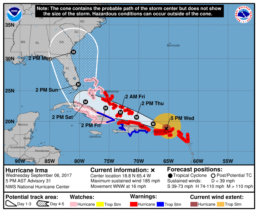
As of 2 p.m. Sunday, downtown Miami appears to be directly in the center of the “awareness cone.”
National Hurricane Center
Thankfully, those projections are far from final, and even if they are final, South Floridians have a ton of time to prepare for any impending cyclone. According to the NHC’s latest update,
“Low vertical wind shear and warm waters along the forecast track of Irma should allow it to remain a very powerful hurricane during the next several days, and the intensity forecast is again near the upper end of the guidance and is the same as the previous advisory through 96 hours,” the NHC wrote. “Increasingly southwesterly shear and potential land interaction late in the period is expected to cause some decrease in Irma’s strength by day 5.”
As of yesterday, it was unclear even which side of the state Irma would land on. It seemed equally likely the storm could make landfall anywhere from Miami to Tampa. This morning, models shifted east — and some hoped predictions would continue shuffling that way and the storm would miss the Florida coastline. This afternoon’s projections offered no further hope.
The most accurate storm models the world has to offer — the Euro, GFS, GEFS, Canadian, and HWRF — all show the storm either grazing dangerously close to Miami or nailing South Florida directly.
Unfortunately the latest Euro is similar to other guidance in having a worst-case scenario for FL's East Coast into the Carolinas #Irma pic.twitter.com/bsn42XGKB3
— Ed Vallee (@EdValleeWx) September 6, 2017
Canadian model also with a west shift since last nights run. #Irma pic.twitter.com/36sIXeRfNz
— HurricaneTracker App (@hurrtrackerapp) September 6, 2017
And finally the HWRF with a west shift as well. Impacts increasing for S FL as we get closer in time. Final track NOT set in stone yet tho pic.twitter.com/0T1TG3gBNX
— HurricaneTracker App (@hurrtrackerapp) September 6, 2017
So, yeah: Things are not looking great for South Florida. With each passing model run, the storm moves closer, meteorologists gain more data, and predictions become more accurate. But we’re still more than far enough out that a lot can change — it is simply impossible right now to accurately say when or where the storm will make landfall. Last October, Miami officials (rightfully) shut down the city in preparation for Hurricane Matthew, which could have leveled major parts of the area. Instead, the storm unexpectedly stayed out to sea and barely touched the coast until it hit the Jacksonville area.
So anything can happen, and it’s best to stay as prepared as possible. There’s a small chance the mountains on the islands of Cuba or Hispaniola could chop up the storm and weaken the system a bit. But as Irma passes through the Caribbean, it’s set to float over a patch of unusually warm water, which means the storm could strengthen again by the time it nears Florida.
Irma has otherwise left little but destruction in its wake. Preliminary images from the Caribbean islands in the storm’s path — Barbuda, Antigua, Saint Martin, the Virgin Islands, and now Puerto Rico — show widespread devastation. In fact, the storm appears to have knocked out the entire communications system for the island of Barbuda — as of 5 p.m., no one has heard from anyone on the island since Irma hit.
The reports from other areas seem awful so far. In Saint Martin,
#Irma: Video shows moment when #Irma hit St. Martin island. pic.twitter.com/V3SqElv7qi
— WorldOnAlert (@worldonalert) September 6, 2017
UPDATE: Devastation in St. Martin caused by Category 5 Hurricane Irma. pic.twitter.com/1N7DIL6ybE
— Abka Fitz-Henley (@AbkaFitzHenley) September 6, 2017
The same goes for Saint Thomas:
VIDEO: St Thomas 2pm — via Drew Alston pic.twitter.com/nBqujQmUlx
— CaribNews (@caribnews) September 6, 2017
As of 5 p.m., the storm was closing in on Puerto Rico, which is all but certain to be severely affected by the storm. The power utility there warned today that the island could be without electricity for an astonishing four to six months. Puerto Rico will need all the volunteer help it can get the minute the storm clears. For now, the first few images from the island aren’t looking great. As of 3 p.m., 300,000 people were without power, and 4,000 had no running water:
For now: Don’t listen to Rush Limbaugh. Prepare for the storm as best you can, and if you think you need to, now is the time to think about getting the hell out of Dodge.