
via Twitter

Audio By Carbonatix
Keep Miami New Times Free
We’re aiming to raise $7,500 by April 26. Your support ensures Miami New Times can continue watching out for you and our community. No paywall. Always accessible. Daily online and weekly in print.
As of 8 a.m. today, Hurricane Irma is still a record-shattering monster in the Atlantic. As the storm churns 15 miles west of Saint Martin, Irma packs 185 mph sustained winds and frighteningly low central pressure of 918 mb. Irma is pounding the Leeward Islands, has Puerto Rico and the Bahamas in its sights, and — as of now — still looks like a very real threat for Florida.
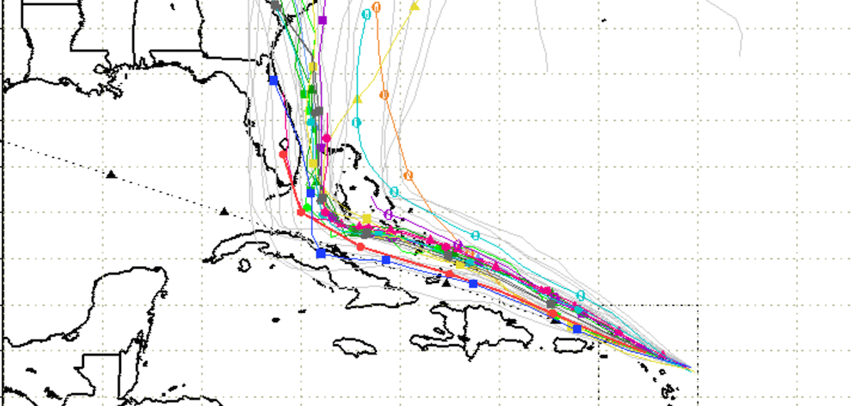
Miamians hoping for respite won’t find it in the 8 a.m. tracking models. Irma’s track has bumped slightly north and east since yesterday, but that just means NOAA’s projections take the storm right over the heart of Florida.
“Irma is a category 5 hurricane,” NOAA writes in its 8 a.m. advisory. “Some fluctuations in intensity are likely during the next day or two, but Irma is forecast to remain a powerful category 4 or 5 hurricane during the next couple of days.”
If there’s any good news, it’s that the trend suggests Irma’s eye wall could stay just off the coast. Here’s one round of the latest spaghetti models.
via NOAA Hurricane Center
But it’s worth remembering that the storm is roughly the size of Ohio, with damaging winds well beyond its powerful eye. And larger spreads still show Miami and the Keys right in the danger zone from the heart of Irma.
Florida should prepare for direct landfall from Category 4 or 5 #IrmaHurricane. Updated spaghetti most concentrated from Keys to Miami. pic.twitter.com/kLenlwgzo8
— Ryan Maue (@RyanMaue) September 6, 2017
Any impacts to South Florida and the Keys would begin Friday night and last through Sunday or Monday, so the storm is still at least three days away from the peninsula. Its track will continue to shift, but it’s looking more and more likely that Miami will at least feel some significant effects from the hurricane.
As a result, Miami-Dade and Miami Beach are both likely to order some evacuations today. Miami-Dade Mayor Carlos Gimenez tells reporters he will probably mandate evacuations in Miami Beach and in the mainland Zones A and B sometime tonight or early Thursday — those zones include low-lying coastal areas from Brickell up through North Miami. (You can figure out what zone you live in by typing your address into Miami-Dade County’s evacuation map.) Miami Beach Mayor Philip Levine is already encouraging Beach residents to leave the barrier island.
In the Keys, meanwhile, authorities began evacuating tourists and nonresidents today at 7 a.m. Residents are supposed to leave beginning at 7 p.m. — the county won’t have any public shelters available during the storm.
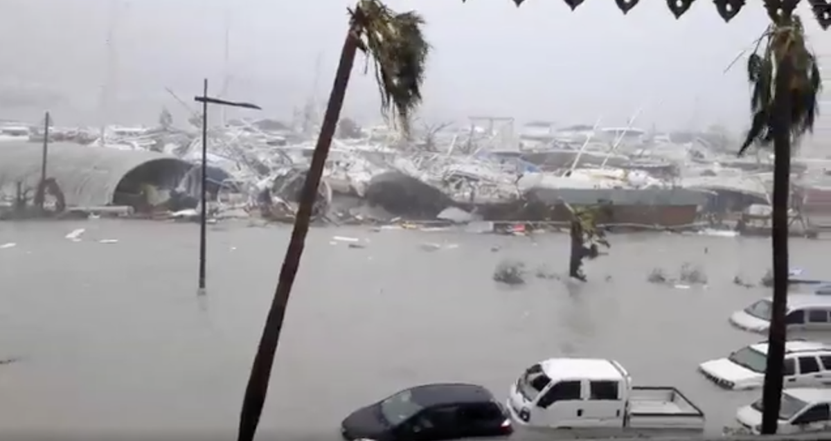
The islands of Saint Martin and Antigua are already feeling Irma’s power. Videos show huge storm surges and devastating wind on the islands:
[IRMA] Saint Martin dans le mur de l'oeil subit les effets de l'ouragan IRMA #iram #ouragan #SaintMartin (Source : Rinsy Xieng) pic.twitter.com/e2j7e9KtOu
— RCI Guadeloupe (@RCI_GP) September 6, 2017
WOWW! #Irma is wrecking Saint Martin… #HurricaneIrma
— Abraham Jr. ® (@torrea40) September 6, 2017
Puerto Rico looks to be in for either a direct hit or a close brush with the storm’s powerful eye wall, and NOAA is calling for some incredible storm surges — the southeastern Bahamas and the Turks and Caicos Islands could see surges of 15 to 20 feet above normal high tide, the weather service warns. Up to 20 inches of rain could fall on parts of Puerto Rico and Cuba.
NOAA will issue its next advisory at 11 a.m.