

Photo by Frank Ramspott/Getty Images

Audio By Carbonatix
On September 1, 2019, Hurricane Dorian made landfall 190 miles east of Miami on Abaco island in the Bahamas as a Category 5 storm – the highest rung of the Saffir-Simpson Hurricane Wind Scale, which the National Hurricane Center uses to classify hurricanes based on their maximum sustained wind speeds. Any storm with maximum sustained winds of 74 mph or more is considered a hurricane and then assigned a category, starting with 1 and then increasing tiers approximately every 15 to 25 mph until reaching 5, the category that officially encompasses all storms with maximum sustained winds of 156 mph or greater.
But Hurricane Dorian, with maximum sustained winds of 185 mph and gusts of up to 220 mph, seemed too powerful to be considered a Category 5. After all, when Hurricane Andrew hit South Florida in 1992 as a Category 5, its maximum sustained winds were alarming at 165 mph yet still considerably less than Dorian’s. Based on the progression between each tier, it’s been speculated that the hypothetical Category 6 rating would start at sustained wind speeds of 182 mph.
“Dorian was the tipping point for me. I kept saying to myself: This feels different than a Category 5,” Richard Olson, director of Florida International University’s (FIU) Extreme Events Institute, tells New Times. “My God, when we’re in the 180s to 200s [mph of sustained wind speeds] – that, to me, has to be another category.”
After Hurricane Patricia’s maximum sustained winds clocked in at 215 mph off Mexico’s Pacific Coast in 2015 and then Dorian at 185 mph in 2019, Olson realized the need to prepare for what he and his team had been referring to internally as “Category 6” storms, despite no such designation existing on the current Saffir-Simpson scale. In 2012, FIU debuted its Wall of Wind, a 12-fan, 8,400-horsepower hurricane simulator that’s currently the largest and most powerful university research facility of its kind. The only problem is that its wind speeds peak at roughly 160 mph and, as the oceans continue to warm, scientists predict a dramatic uptick in the frequency of ultra-intense megastorms like Patricia and Dorian from occurring once every eight years in the late 20th Century to roughly one megastorm a year by 2081.
“We need to get ahead of what nature is throwing at us,” Olson says. “We have to get ahead of this. I don’t want my kids and grandkids saying, ‘You knew this. Why didn’t you do anything? Why didn’t you research this issue when you had the chance?'”
The good news is that Olson and his team at the Extreme Events Institute were recently awarded a $12.8 million grant from the U.S. National Science Foundation to design a full-scale testing “Cat 6 prototype facility” with wind speed capabilities of up to 200 mph. Olson estimates it’ll be four times the size of the Wall of Wind and comparable in size to a small football stadium. The project is still in its initial design and planning stage, with FIU’s Department of Civil and Environmental Engineering leading a multidisciplinary team of researchers from eight other schools, including Stanford University, the Georgia Institute of Technology, and the University of Florida. The proposal still has to be approved, but Olson thinks the new facility could be up and running by 2030.
The biggest upgrade, though, isn’t the facility’s wind speeds but its water basin, Olson explains. For the first time, researchers and engineers will be able to test not just how buildings and infrastructure respond to extreme winds but also the combined effects of extreme winds, storm surges, waves, and flooding.
“We’re trying to get a handle on all the components of a hurricane – not just wind and rain, but understanding how the wind interacts with the water,” Olson says. “Frankly, it’s the water component that’s most dangerous to human beings.”
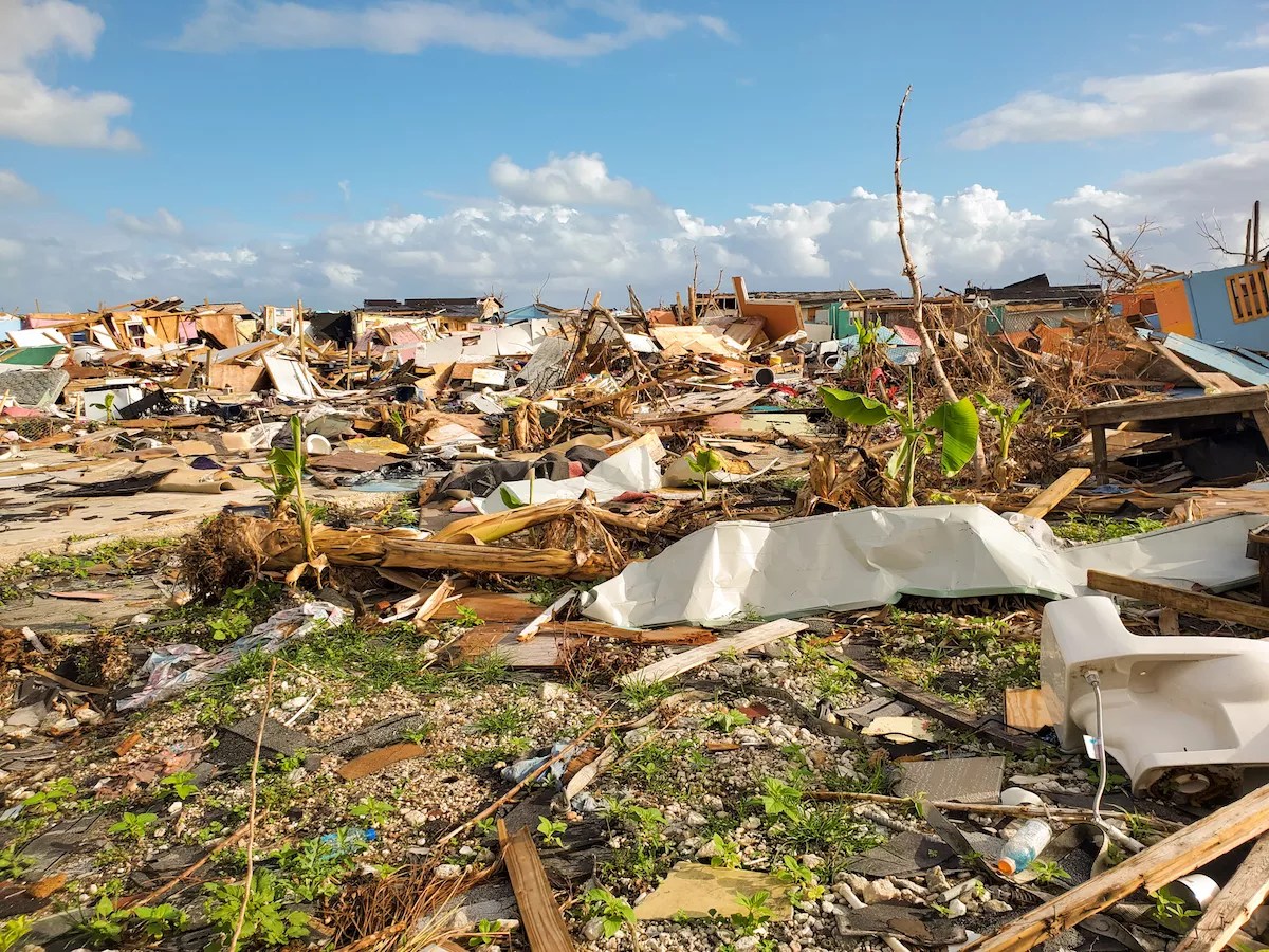
The devastation in Abaco’s Marsh Harbour after Hurricane Dorian made landfall on October 1, 2019.
Photo by Branden Hoolehan/Getty Images
The Saffir-Simpson scale was developed in the early 1970s by Coral Gables structural engineer Herb Saffir and the National Hurricane Center director at the time, Robert Simpson. It’s since become the predominant measure among meteorologists for depicting the strength of hurricanes. But after Hurricane Dorian, there have been increased calls for the hurricane center to modify its ranking system or abandon it altogether.
“Don’t be fooled by the Saffir-Simpson scale of the storm. It’s got several problems,” Jeff Masters, a meteorologist for Yale Climate Connections, tells New Times. “Number one, it’s just a wind scale. So it doesn’t capture the threat of storm surge or freshwater flooding from heavy rains.”
This can lead to the public underestimating the threat of bigger storms with lower wind speeds, which tend to rank lower on the Saffir-Simpson scale but still carry substantial risk due to storm surge and inland flooding. It’s especially dangerous considering that a 2014 study by Edward Rappaport, deputy director of the hurricane center, found that 90 percent of all hurricane deaths are water-related, with most people drowning in storm-surge floods or rainfall-induced freshwater floods and mudslides.
Hurricane Sandy, for example, was a Category 1 storm when it made landfall near Atlantic City, New Jersey, in 2012. But as one of the largest hurricanes ever recorded, it caused substantial rain and flooding: 72 people died in the U.S. and there was $70.2 billion worth of damage. In 2008, 113 people died in the U.S. as a result of Hurricane Ike, even though it was a Category 2 storm when it made landfall in Galveston, Texas.
“A lot of people are caught off guard because they said, ‘Oh, it’s only Category 2,'” Masters says. “The takeaway message is that you don’t need a Cat 5 [hurricane] to get catastrophic damage.”
The National Hurricane Center currently issues storm-surge watches and warnings separate from its Saffir-Simpson scale. But Masters has long considered alternative ways to more accurately depict the threat of upcoming storms to the public. He’s thought of creating two additional Saffir-Simpson-type scales in addition to wind speed: one for storm-surge threat and another for freshwater flooding.
“But that might be too complicated,” he admits.
He has also wondered about the European Medium Range Forecast Model, which issues a simple color-coded yellow, orange, or red threat based on the combined effects of winds, storm surge, floods, and other variables. There’s also something called the Integrated Kinetic Energy (IKE) metric, which accounts for the intensity and size of the storm and is said to be “more representative of its destructiveness.”
“The oceans are heating up, and hurricanes derive their power from heat in the water,” Masters notes. “There has been a 10 percent increase in major hurricanes globally, and the strongest storms are definitely getting stronger worldwide.”
It’s only a matter of time before one of these megastorms makes landfall in the U.S. Masters considers FIU’s Category 6 prototype facility integral to preparing for storms of that magnitude.
“We need to be doing this work,” he says. “If we know ahead of time what these storms are capable of, we can design a response to the threat, get people out of harm’s way, protect our infrastructure the best we can before the storm hits, and maybe change some of our practices so that we don’t build in harm’s way to the degree we’re doing now.”