Update: By 7 a.m. Tuesday, Michael's landfall had been pushed back to Wednesday and the forecast wind tracking moved a bit north, so South Florida seemed less likely to suffer serious damage. Much rain and some winds still seem likely beginning late Tuesday night or Wednesday morning.
Hurricane Michael continued strengthening this afternoon and could deliver strong winds and heavy rain to Miami by early Tuesday.
By 2 p.m. Monday, the storm's strength had reached 75 mph, and as it moves away from Cuba, it's expected to strengthen all the way through Wednesday, when wind speeds might hit 120 mph, making Michael a strong Category 3.
Maximum rain could be 12 inches on the Gulf Coast of North Florida. The Keys are expected to receive two to four inches of rain, with South Florida somewhere in between, the National Weather Service reported. Miami is on the wet side of the storm, so flooding here could be significant. The early-afternoon forecast put the odds of the city receiving tropical storm-force winds around 10 percent.
This past Sunday, Gov. Rick Scott issued a state of emergency in 35 counties in the storm's path, most on the Gulf Coast. Neither Miami-Dade nor Broward was among them.
Tallahassee mayor and gubernatorial candidate Andrew Gillum canceled campaign stops from Pensacola to Gainesville. He and Scott spoke on the phone Wednesday and, according to the Tampa Bay Times, the storm could have "significant implications" on the midterm elections. Gillum, the paper noted, is the public face of the state capital.
Moreover, the death of 12 seniors in a Hollywood nursing home during last year's Hurricane Irma — for which the governor has been significantly blamed because he didn't help despite many phone calls — has not been mentioned in Scott's Senate race against incumbent Bill Nelson.
Coinciding with the king tide, as well as the invasion of red tide, on the state's east coast, the storm is also predicted to cause unexpected damage in Miami. This post will be updated as more information becomes available.
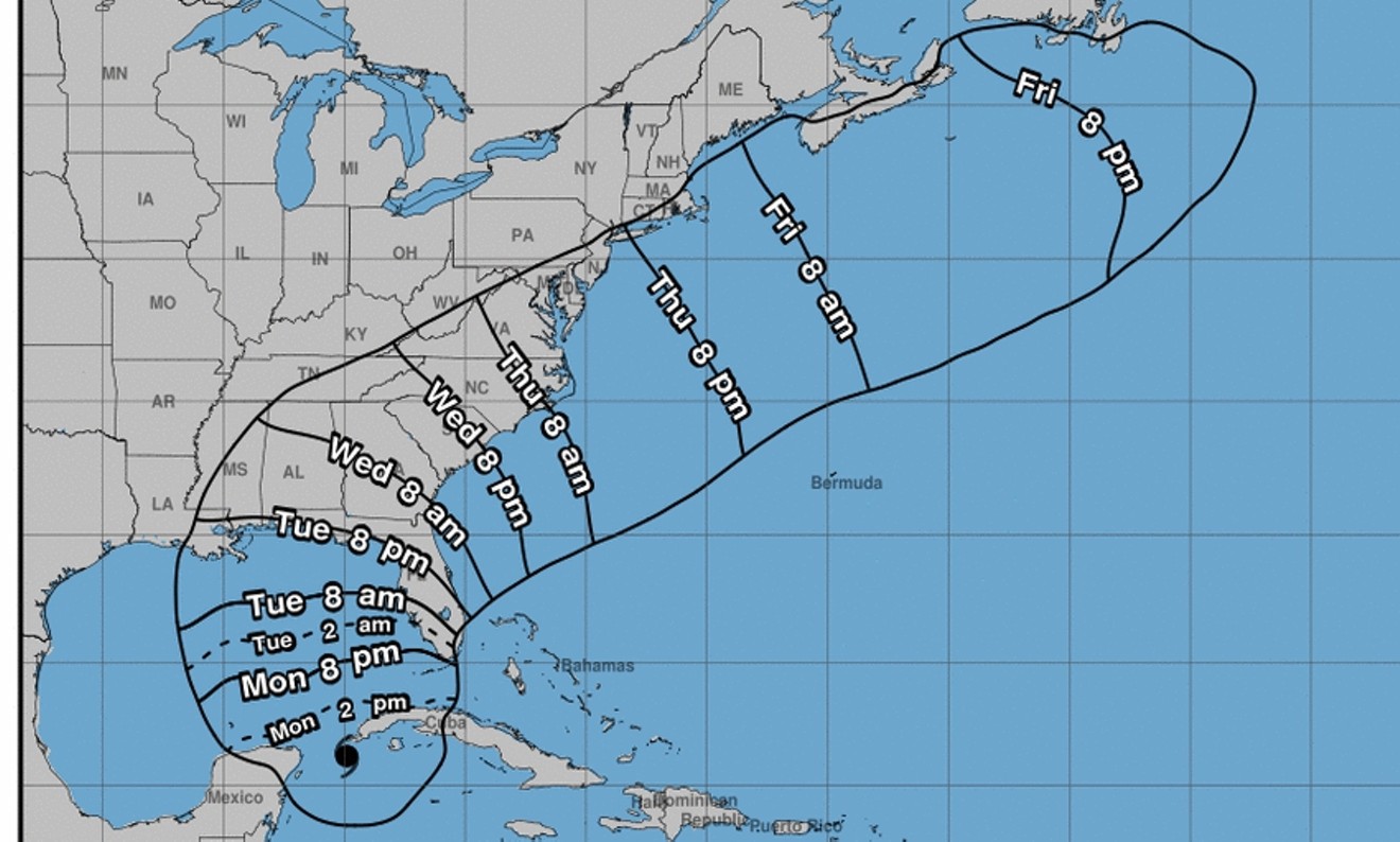
Wind arrival times
National Weather Service
[
        {
          "name": "Air - MediumRectangle - Inline Content - Mobile Display Size",
          "component": "19274298",
          "insertPoint": "2",
          "requiredCountToDisplay": "2"
        },{
          "name": "Editor Picks",
          "component": "17482312",
          "insertPoint": "4",
          "requiredCountToDisplay": "1"
        },{
          "name": "Inline Links",
          "component": "18711090",
          "insertPoint": "8th",
          "startingPoint": 8,
          "requiredCountToDisplay": "7",
          "maxInsertions": 25
        },{
          "name": "Air - MediumRectangle - Combo - Inline Content",
          "component": "17482310",
          "insertPoint": "8th",
          "startingPoint": 8,
          "requiredCountToDisplay": "7",
          "maxInsertions": 25
        },{
          "name": "Inline Links",
          "component": "18711090",
          "insertPoint": "8th",
          "startingPoint": 12,
          "requiredCountToDisplay": "11",
          "maxInsertions": 25
        },{
          "name": "Air - Leaderboard Tower - Combo - Inline Content",
          "component": "17482313",
          "insertPoint": "8th",
          "startingPoint": 12,
          "requiredCountToDisplay": "11",
          "maxInsertions": 25
        }
      ]


KEEP NEW TIMES FREE...
Since we started New Times, it has been defined as the free, independent voice of Miami, and we'd like to keep it that way. Your membership allows us to continue offering readers access to our incisive coverage of local news, food, and culture with no paywalls.
You can support us by joining as a member for as little as $1.


Trending


Use of this website constitutes acceptance of our
terms of use,
our cookies policy, and our
privacy policy
The Miami New Times may earn a portion of sales from products & services purchased through links on our site from our
affiliate partners.
©2024
Miami New Times, LLC. All rights reserved.
Do Not Sell or Share My Information
Do Not Sell or Share My Information
